Shiretoko
- Published on : 15/10/2020
- by : G.L. / O.F.
- Youtube
Local Time 05:33
Symbol : sunny
Temp : 20.1°C
Date : Today
Symbol : sunny_cloudy
Temp : 27.1°C
Date : Tomorrow
Symbol : sunny_cloudy
Temp : 21.5°C
Date : Wednesday
Symbol : cloudy
Temp : 15.4°C
Date : Thursday
Local Time 05:33
Symbol : sunny
Temp : 20.1°C
Date : Today
Symbol : sunny_cloudy
Temp : 27.1°C
Date : Tomorrow
Symbol : sunny_cloudy
Temp : 21.5°C
Date : Wednesday
Symbol : cloudy
Temp : 15.4°C
Date : Thursday
Shiretoko, Hokkaido: Where nature roams free
At the eastern end of the island of Hokkaido, there is one of the most beautiful locations in Japan, Shiretoko, a natural and protected nature conservatory. Shiretoko is the mountainous peninsula that stretches towards the Kuril Islands, in the most northeastern sector of Hokkaido.
The Shiretoko Peninsula
In the language of the Ainu, the indigenous hunter-gatherers of Hokkaido, the word sir-etok meant "the end of the land". With the Japanese takeover of the region in the Meiji period, Sir-Etok became Shiretoko. The "end of the land" moniker is still relevant today.
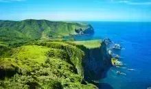
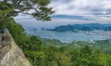
The peninsula's coastline is rugged and lined with high rocks. It is made up of high mountains, Rausu-dake being the highest at 1,660 m, and its forests are home to the largest population of brown bears in Japan. Almost the entire peninsula is a UNESCO World Natural Heritage Site.
Shiretoko is where the land ends, where the last bears in Japan can be seen, where sea lions swim in the open sea, where nature reigns supreme, and where man has seldom set foot. Shiretoko is the natural jewel of Hokkaido Island, and with its rugged terrain, steep cliffs, and deep lakes, it requires a long journey that is well worth it.
- Read also: The Ainu of Japan
Hiking in Shiretoko
The peninsula, which stretches out to the northeast of Japan towards the Sea of Okhotsk, is both a protected natural park and a UNESCO-listed area. At its center is the Shiretoko Pass, at the foot of the Rausu Volcano. In the south, the park is organised to minimize mass tourism and promote the protection of the natural area. Hikers get information at the Shiretoko Nature Center and follow marked trails that lead to the Furepe Falls - a sumptuous panorama of a creek and a waterfall that gushes down the side of the cliff. A shuttle bus is required to access the Five Lakes Walk and Kamuiwakka Waterfall.
North of the pass, Shiretoko becomes "off-piste," deviating from easily navigable trails to hikes that are reserved for experienced and equipped mountaineers: no telephone network, no human presence, but a large bear population... Walking in this part of Shiretoko requires preparation and equipment. The local authorities actually restrict direct access to the cape due to the wildlife there except for a select few.
But even without being the most adventurous of mountaineers, the Shiretoko which has general access, is a tourist's dream. Listen out for the cry of sea eagles or the sound of bells in the distance (they are attached to the backpacks to ward off any bears), discover tiny frogs and myriads of dragonflies on the edge of a lake, bathe in natural hot water pools to rest legs aching from the climb...
Utoro City
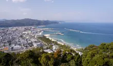
Located on the west coast of Shiretoko, Utoro is the main tourist center for the area. Its large visitor center has all the practical information about the peninsula, there are plenty of hotels, hostels, shops, and restaurants offering the best of what the local fishermen have brought in from the sea.
Right in the center of the town is a large fishing port. There are many restaurants right next to the harbor offering the fish that the nets have caught: large crabs, sea urchins, and generous amounts of ikura salmon roe. Hokkaido is famous for these dishes, and this is one of the best places on the island to eat them fresh.
Just behind the fishing harbor is Oronkoiwa Rock and it is worth climbing it to see the fishermen bringing in their catch and heading for the northern coast of the peninsula. Tour boats of all sizes leave and return in quick succession.
Next to the fishing harbor is the tour boat harbor, and on the street leading to it, one tour boat company after another offers its services. Excursions range from a visit to Cape Shiretoko, to the end point of the peninsula, to shorter tours. They include a trip to a beach where brown bears frequently roam and a walk to Kamuiwakka Falls, the latter taking just over an hour in total.
Cape Shiretoko: Kamuiwakka Falls and Rusha River
The area around Cape Shiretoko is closed to all but a few wildlife researchers. Even though Utoro is a busy tourist town, the World Heritage National Park just behind the town is working hard to protect the wildlife that lives there.
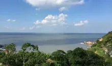
The view from the sea is magnificent, however. The coastline is rocky and wild, and many small rivers flow into the sea from high rocks.
The Kamuiwakka Falls are the most spectacular. They flow down three large steps before reaching the sea. They are actually made up of hot water laden with minerals and flow directly down from Mount Iou-dake. Mount Iou is a volcano, Iou meaning sulphur. Today, Kamuiwakka Falls is one of the few areas in the national park that is also accessible by land. To get there, drive up the road to Rausu and park your car at the Shiretoko Nature Centre (Shizen Sentaa).
It is possible to bathe in the hot pools of water formed by the falls while looking out to sea, and it is an unforgettable experience.
Beyond the falls, the road continues until it meets the Rusha River. This part of the road, however, is closed to all traffic and takes you directly into the land of free-roaming bears. Beyond the Rusha River begins the forbidden zone. Here, the bears rule.
From the end of April to the beginning of November, the road between Utoro and Rausu is open to traffic. Make sure you take a drive, as it is a spectacular view. Stop at the car park at the top of the pass and look east towards Rausu. You'll have a great view of the mountains and sea and, weather permitting, the island of Kunashiri.
The town of Rausu and the Seseki Onsen
The town of Rausu is the opposite of Utoro. Much less touristy than Utoro, you won't find any big hotels or travel agency advertisements on the buildings. Rausu is an unpretentious, modest fishing town. It does, however, offer whale-watching trips most of the year.
From Rausu, a road leads up to the peninsula. All the way to the end, it is lined with small fishermen's houses. At the end of the road you will find Seseki Onsen, an onsen pool built right into the sea. You can only access it at low tide, as high tide submerges it completely under water.
But this is not a tourist onsen, you have to ask permission to use it at the fisherman's house next door. Permission will be granted if the tidal situation is good and the locals do not need it for themselves.
The famous drift ice of Shiretoko:
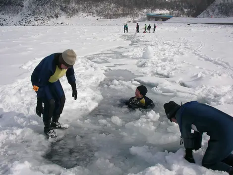
One of the most recognizable features of Shiretoko is the drift ice, known as ryuhyo (流氷) in Japanese. The ice comes from the Sea of Ohkotsk in northeastern Russia, usually first seen in January every year and staying around until April.
Under ideal conditions, the drift ice is actually able to be walked on and creates a one-of-a-kind view, but even when the ice is less stable, ice swimming (with proper warming equipment, of course) is often done, the ice creating a jigsaw-puzzle-like natural scene that must be seen to be believed.
Also common during this time is bird-watching, often done on boats taken out on to the water to also see the drift-ice up and close as well.
Conseils pratiques et sécurité pour visiter Shiretoko
En raison de son caractère sauvage et isolé, une visite à Shiretoko nécessite quelques préparatifs et précautions. La présence d'ours bruns représente un facteur de risque à ne pas négliger. Si vous partez en randonnée, informez-vous toujours au préalable au centre d'information du parc sur les dernières observations d'ours et les éventuelles fermetures de sentiers. Il est recommandé de faire du bruit pendant la marche pour signaler votre présence, par exemple en parlant fort ou en attachant une petite clochette à votre sac à dos.
Pour les sentiers terrestres des cinq lacs, une réglementation stricte est en vigueur. Du 10 mai au 31 juillet, période de haute activité des ours, les randonnées ne sont autorisées qu'accompagnées d'un guide certifié. Le reste de l'année, l'accès est libre moyennant des frais d'entrée, mais les sentiers peuvent être fermés en cas de présence d'ours.
Il est important de ne jamais transporter de nourriture lors des randonnées pour ne pas attirer les animaux sauvages (seule l'eau est autorisée). Évitez également de vous approcher des ours ou de tout autre animal sauvage si vous en apercevez.
En ce qui concerne la météo, consultez toujours les prévisions avant de partir car les conditions peuvent changer rapidement. Même en été, prévoyez des vêtements chauds car les températures peuvent chuter, surtout en altitude. En hiver, équipez-vous en conséquence pour affronter les températures négatives.
Pour les activités hivernales sur la banquise, suivez scrupuleusement les instructions des guides. Les excursions ne sont proposées que lorsque les conditions sont sûres, mais les sorties peuvent être annulées à la dernière minute en cas de changement météorologique.
Enfin, prévoyez suffisamment d'argent liquide, car les distributeurs automatiques sont rares dans cette région isolée, et tous les commerces n'acceptent pas les cartes de crédit.
Où séjourner et que déguster dans la région
Pour profiter pleinement de votre séjour à Shiretoko, plusieurs options d'hébergement s'offrent à vous. Utoro, sur la côte ouest, est le principal centre touristique de la région et propose une variété d'hébergements, des grands hôtels aux auberges traditionnelles (ryokan). Le Kitakobushi Shiretoko Hotel & Resort est particulièrement apprécié pour son onsen (bain thermal) avec vue sur la mer et son restaurant servant des fruits de mer frais. Situé à seulement 5 minutes de marche du rocher Oronko, cet établissement offre également un salon commun avec accès à des boissons gratuites et une vue magnifique sur le port.
Pour une expérience plus authentique, la pension Kifu Club à Utoro propose un hébergement de type chalet japonais avec onsen extérieur, idéal pour se relaxer après une journée d'exploration. Vous y trouverez une ambiance chaleureuse et familiale.
Guide de voyage de l'île d'Hokkaido, dont Shiretoko fait partie, est réputée pour sa gastronomie, en particulier ses fruits de mer d'une fraîcheur incomparable. À Utoro, de nombreux restaurants bordent le port de pêche, proposant les prises du jour : crabes géants, oursins et généreuses portions d'ikura (œufs de saumon), spécialités pour lesquelles Hokkaido est célèbre.
Ne manquez pas de goûter à l'uni-don, un bol de riz surmonté d'oursins frais, particulièrement délicieux entre fin juin et août lorsque les oursins sont à leur apogée. Le jingisukan (agneau grillé), nommé d'après Gengis Khan, est une autre spécialité locale, idéale pour se réchauffer pendant les mois froids. Pour une expérience culinaire unique, essayez le zangi, poulet frit mariné originaire de la ville de Kushiro, devenu un élément incontournable de la cuisine locale.
À Rausu, ville de pêcheurs moins touristique qu'Utoro, les restaurants sont plus authentiques et moins nombreux, mais la qualité des fruits de mer reste exceptionnelle. Pour une expérience vraiment unique, rendez-vous au Seseki Onsen, un bain thermal naturel construit directement dans la mer et accessible uniquement à marée basse. Pour y accéder, il faut demander l'autorisation au pêcheur dont la maison se trouve à proximité.
Entre dégustations de produits frais de la mer et moments de détente dans les onsen naturels, votre séjour à Shiretoko sera aussi un voyage culinaire et de bien-être, récompensant après les longues journées d'exploration dans cette nature sauvage et préservée.
Our tours in Shiretoko
Interested by Shiretoko
Discover other cities to explore


