Tokyo Hikes
- Mount Takao
- Mount Mitake
- Mount Mitsumine
- Kamakura
- Mount Oyama
- Mount Tsukuba
- Mount Fuji
- Kinchakuda Higanbana Fields & Mount Hiwada
- Mount Buko
- Mount Nokogiri
- Books on Hiking in Japan
Tokyo Hikes ハイキング
Tokyo may be one of the largest and most crowded cities on earth but Japan's quick and efficient transport system means Tokyoites can be walking up a wooded mountain slope in a little under two hours in some cases.

Mount Mitake - an ideal location for communing with nature and relieving big city stress
Hiking the mountains around the Tokyo metropolitan area is a great way to keep fit and promote all-round well-being through shinrin-yoku (lit. "forest-bathing") or a deep immersion in the healing power of nature.
Head for the hills closest to Tokyo to observe the blooming of cherry blossoms during hanami season in March and April and Kyoto's spectacular fall colors or kouyou (紅葉) in the autumn months.
The two nearest and most popular hikes from Tokyo are Mt. Takao and Mt. Mitake both within two hours of Shinjuku, but if you expand your horizons (and set your alarm clock accordingly!) to include more of the surrounding Kanto area many more destinations become within reach.

Hiking on Mount Takao

Distant view of Mt. Fuji from Mt. Takao
Tokyo Hikes
Mount Takao 高尾山
Just 40km west of Shinjuku, Mount Takao (Takao-san), once the preserve of Shugendo ascetics, is now an easily accessible refuge for stressed out city dwellers. Though itself crowded on weekends and national holidays, Mount Takao, part of the Meiji no Mori Takao Quasi-National Park, can offer the perfect getaway on weekdays and is a refreshingly cooler spot in the heat and humidity of a Tokyo summer. Mount Takao is an especially popular destination during the plum blossom season in February and for viewing autumn leaves in November. There are a variety of hiking trails on the mountain, focussing on different aspects of plants, forests, history and temples. Mount Takao is also the start of the 1,700 km (over 1,000 mile) Tokai Nature Trail that goes all the way to Mino in the Kansai region. The Visitor Centre has maps and further information.
Access
A trip to Takao san really needs a full day to get there and back and to appreciate its possibilities. The easiest and cheapest way to get there is to take the Keio Takao Line train from Shinjuku Station. Start with a semi-special express to Kitano Station and change there to a local train for Takaosanguchi Station. It takes about an hour and costs 390 yen. From Tokyo Station, take the JR Chuo Line Rapid ("Kaisoku") train to Takao Station, then change to the Keio Takaosan Line and get off at Takaosanguchi. From Tokyo, the ride takes about 1 hr 20 minutes.
Read more about Mt. Takao

Mount Mitake, Omi city
Mount Mitake 御嶽山
Mount Mitake, 929m tall, offers good views over the Kanto Plain towards the Tokyo skyline, a wealth of both historical and natural attractions, as well as plenty of hiking trails. From the upper station of the Mitake Cable Car there is an observation area, equipped with coin-operated telescopes, from where on clear days, the Tokyo skyline with its Shinjuku / Ikebukuro high-rises and the Tokyo Skytree is clearly visible. It's possible to hike up the mountain direct from the train station from where a path leads to the historic Musashi Mitake Shrine. More trails lead to the Nanayo and Ayashiro waterfalls, others to impressive ancient cedar trees and onward in about one hour to the neighboring mountains of Mount Hinode (日の出山) and Mount Otake.
Access
Tourist brochures promoting visits to Mount Mitake point out that the mountain is only a 90 minute train trip away from central Tokyo - "Central Tokyo" meaning Shinjuku Station and the "90 minutes" presumes a well-planned itinerary. But, from Ome Station, where you have to change trains on the way to JR Mitake Station, trains for Mitake / Okutama run only about once an hour. From Tokyo Station or Shinjuku Station, take the Chuo Line to Ome Station and change there to the Ome Line. Alternatively, take the Chuo Line to Tachikawa and change there to the Ome Line. From Ome Station, only about one train per hour goes to Mitake / Okutama. From Mitake Station, take bus number 10 to Cable Shita (280 yen). Walk from the Cable Shita bus stop to Takimoto Station and take the cable car. The cable car return trip fare is: adults 1,110 yen, children 560 yen. One-way trip: adults 590 yen, children 300 yen. The Mitake cable car operates from 7.30am to 6.30pm.

Zuishinmon Gate, Mitsumine Shrine
Mount Mitsumine 三峯山
Mount Mitsumine in Chichibu-Tama-Kai National Park is home to the beautiful Mitsumine Shrine, often described as one of Japan's most beautiful mountain shrines. A visit to the mountain on a day-trip from Tokyo usually includes seeing Lake Chichibu. From Mitsumine Shrine there are onward trails to Mount Kumotori - a day's hike away.
Access
Take the Seibu Line train to Chichibu - the Red Arrow Express going straight from Ikebukuro Station is advertised as covering the distance in a mere 78 minutes. Right outside Seibu Chichibu Station, hop on the bus to the shrine. The bus will take a little more than an hour to reach Mitsumine Shrine. If you wish to walk up the mountain take the Chichibu Line from Chichibu Station to Mitsumine-guchi Station (between 23-30 minutes) then a local bus (15 minutes to the Owa bus stop).
Kamakura 鎌倉
The historic sights of Kamakura make for a easy day-trip from Tokyo and a great way to see the Great Buddha and the other temples is to follow the three hiking trails here: Daibutsu, Gionyama and Tenen. Details on the walk are available at the Tourist Office at Kamakura Station.
Access
From Tokyo Station take the JR Yokosuka Line to Kamakura Station (1 hour; 920 yen).

View over the Tanzawa-Oyama Quasi-National Park, Kanagawa
Mount Oyama 大山
Mount Oyama, part of the Tanzawa-Oyama Quasi-National Park, is one of the easiest to access hiking spots from central Tokyo. It is known as a holy mountain to the Japanese, and many people visit for religious reasons, rather than to exercise or to see the views.
Located in Kanagawa Prefecture, Mount Oyama shares the same kanji as Mount Daisen in Tottori Prefecture, but has a completely different reading.
Mount Oyama is not as busy as Mount Takao or Mount Mitake, but offers the conveniences of these places, such as a good rail and bus network to connect hikers with the various trails and other attractions. Mount Oyama is a great way to enjoy a quiet day away from the busyness of big city Tokyo.
Access
Take an Odakyu Line from Shinjuku Station to Isehara Station (586 yen, 55 minutes). Getting the Tanzawa-Oyama Freepass from Odakyu Railway includes the return train ride, plus the use of buses to the trail heads. The pass costs 1,530 yen with use of the buses, or 2,470 yen including the buses and cable car. Children are half price.

The twin peaks of Mount Tsukuba, Ibaraki Prefecture
Mount Tsukuba 筑波山
Mount Tsukuba in Tsukuba, Ibaraki Prefecture, is a doable day hike from Tokyo if you start early enough. The twin peaks of the mountain are Nyotai-san at 877m and Nantai-san at 871m - "Male Mountain" and "Female Mountain" respectively. Tsukuba-san Shrine at the summit is fittingly dedicated to happy marriage and match-making. Visitors can reach the peaks on one of the many hiking trails (about one hour's walk) or by cable car or ropeway. There are tremendous views over the Kanto Plain below as far as Tokyo and the Sky Tree.
Access
Buses run from Tsukuba Bus Station outside Tsukuba Station to both the cable car and ropeway stations at the foot of the mountain (40 minutes; 720 yen). From Akihabara Station the fastest Tsukuba Express takes 45 minutes to Tsukuba.

Sunset on Mount Fuji
Mount Fuji 富士山
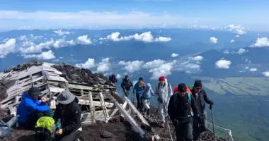
Mount Fuji is Japan's iconic symbol, long considered sacred, and its highest mountain, at 3,776 meters (12,388 feet). Located between Shizuoka and Yamanashi prefectures, it is part of the Fuji-Hakone-Izu National Park. Climbing Mt. Fuji is a hike that many residents of and visitors to Japan want to accomplish at least once in their lives, most during the main hiking season in July and August. Be warned, however, ascending Japan's highest mountain is a challenging, strenuous activity and the rapid ascent to over 3,000 meters can lead to health problems due to altitude sickness for even the fittest individuals. Don't climb Fuji expecting solitude, the mountain is busy and getting more so. The trails are also bare with treacherous loose rocks and scree. The climbing season on Fuji runs from from early July until early September on the Yamanashi side and from early July until early October on the Shizuoka side. It is possible to leave Tokyo, climb Mount Fuji and get back in a day, just.
Access
Kawaguchi-ko and Fuji Yoshida are the main points of access for climbing Mount Fuji. From the Kanto area there are buses from Busa Shinjuku in Tokyo (around two hours depending on traffic) to Kawaguchi-ko and the 5th Station. Trains from Shinjuku take longer than the more direct bus link. If you are travelling by train, take the JR Chuo Line to Otsuki then change to the Fujikyu Line to Kawaguchi-ko, then a bus to the 5th Station. There is a direct early morning train from Shinjuku at weekends and public holidays during the summer season. Alternatively take an Odakyu Line train from Shinjuku Station to Gotemba (1 hour, 40 minutes) and then a bus just over an hour to Fuji Yoshida. By car take the Chuo Expressway to Otsuki Interchange and then the southern spur of the Chuo Expressway to Kawaguchiko Interchange. By car from the Kansai and Chubu areas, ride the Tomei Expressway from Nagoya to the Gotemba Interchange then National Highway 138 north west to Kawaguchiko. The nearest shinkansen stop for visitors from western Japan is Shin-Fuji from where there are buses to Kawaguchiko (for Fuji Five Lakes) or take the JR Tokaido Main Line to Fuji Station then transfer to the JR Minobu Line to Fujinomiya.
Kinchakuda & Mount Hiwada 高巾着田, 被和田山
Kinchakuda in Saitama Prefecture is known for its fields of higanbana (Cluster Amaryllis), the largest in Japan. Nearby Mount Hiwada has a height of only 305m, but since all the land south of it is more or less flat, it offers a great view onto the whole of the Tokyo skyline with the Sky Tree, the high rises of Ikebukuro and Shinjuku and beyond even on slightly hazy days. Mount Fuji can also easily be spotted from up here.
Access
From Ikebukuro Station take the Seibu Ikebukuro Line to Hanno, change to the Seibu Chichibu Line local train, get off at Koma Station. Total journey time on the train is just under an hour to cover the approximately 50km. The fare is presently 530 yen. Then walk about 15 minutes to Kinchakuda.
Mount Buko 武甲山
Mount Buko is certainly one of the strangest looking mountains in Japan. Towering over Chichibu city in western Saitama Prefecture, the 1,304 meter high Buko-san looks as if the Chichibu side of the mountain had been gnawed at by a giant animal. The giant animal feeding on the mountain has been the Tokyo construction industry. Mount Buko consists almost entirely of limestone, a vital ingredient to the millions of tons of cement that have been needed to build all the skyscrapers and urban infrastructure of modern Tokyo. The hike to the summit on the reverse (non-quarried) side passes through a cedar plantation forest with a few pleasant streams and waterfalls along the way. Views on a clear day can be spectacular.
Access
Take the Seibu Express train from Ikebukuro Station to Hanno, change there to the local Seibu Chichibu line, get off at Yokoze Station. Walk from there.
By car: travel route 299 towards Chichibu, turn left at Ubugawa Junction (生川入口) in Yokoze, shortly before Chichibu.
Mt Nokogiri 鋸山
Mount Nokogiri (Nokogiriyama in Japanese, 330 meters at its highest peak) is a rather long mountain stretching in an east - west direction along the border of the city of Futtsu with the town of Kyonan in the southern part of the Boso Peninsula in Chiba Prefecture. Its name translates as "Saw Mountain" and if you look at it from a distance, the mountain ridge with its wooded peaks and depressions does remind somewhat of a traditional Japanese saw.
The western edge of the mountain falls steeply towards the Uraga Channel, the narrow entrance from the Pacific Ocean into Tokyo Bay. Mt. Nokogiri offers great viewpoints and a wealth of ancient Buddhist stone sculptures and rock carvings in a setting of beautiful landscape.
Access
From Tokyo, take a JR Chuo Line train to Chiba Station. There, change to the JR Uchibo Line to Hama - Kanaya Station (if you want to use the Nokogiri Ropeway lift) or to Hota Station if you want to walk up the steps from Nihon-ji Temple.
Books on Hiking in Japan
Alan Booth's classic Roads to Sata details the author's epic journey on foot from Hokkaido to Kyushu and remains one of the best pieces of travel writing on contemporary Japan. Published posthumously, his Looking For The Lost: Journeys Through A Vanishing Japan is another great book about walking in Japan.
New Zealand adventurer Craig McLachlan has written extensively on his walking adventures in Japan. He has traveled two pilgrimage routes, the Shikoku Henro (Tales of a Summer Henro), and the Shikoku Kannon Pilgrimage (Wandering with Basho), as well as climbing many mountains, including the 100 Famous Mountains (Hyakumeizan - the 100 Mountain Challenge) and all of Japan's mountains with peaks higher than 3,000 meters (Japan: Coast to Coast), so it's hardly surprising that he co-authored Lonely Planet's Hiking in Japan.
JapanVisitor's Jake Davies has walked both the 1,200 kilometer Shikoku Pilgrimage and 2,000 kilometers around Kyushu. You can follow his travels and superb photography on his Kyushu 108 Sacred Sites Pilgrimage.
Related Japan Nature Links
Hiking in Japan
Hiking in Kyoto
List of Parks and Gardens in Japan
Tokyo Cherry Blossom Spots
Tokyo Best Fall Colors Spots
Kyoto Cherry Blossom Spots
Kyoto Fall Colors
Books on Tokyo
Tokyo hikes: suggested hiking from Tokyo at Mount Takao, Mount Mitake, Mount Mitsumine and Kamakura.
