Kikaijima 喜界島

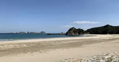
Beach on the island of Kikai_Kagoshima
Tsuda, Wikimedia
coral island
Kikai Village is actually an island, Kikaijima, also called Kikaiga-jima. This small island of 48.6 kilometers in circumference with less than 8,000 inhabitants is unique in many ways.
Kikaijima is part of the Satsunan Islands, in the Amami Archipelago, located between Kyushu and Okinawa, in Kagoshima Prefecture.
See also: Amami-Oshima Island
Land richness and cultural richness
Born from coral reefs thousands of years ago, Kikai continues to be uplifted by corals and its level is rising by 1.8 millimeters per year, making it one of the fastest rising coral islands. in the world.
Rich in minerals, its lands are fertile and there are many crops. Little touched by tourism, the nature is intact there , the luxuriant vegetation, the century-old trees, in particular its magnificent banyan trees and its sugar cane plantations have provided for centuries one of the best brown sugars in Japan.
Kikaijima was in turn independent, governed by the kingdom of Ryûkyû and occupied by the United States (from the end of the Second World War to 1953) before being attached to the prefecture of Kagoshima . This historical particularity and its remoteness have favored the development of a culture that is all the more unique as each village has its own customs and sometimes even its own dialect . In some parts of the island, Kikai is still spoken, one of the endangered languages of the Ryukyu archipelago.
To read: Dialects in Japan
Rocky coasts, limestone cliffs but also pretty white sand beaches border the little Kikai. Scuba diving (there are two diving centers) and snorkeling are among the attractions of the island and the less cautious can swim there from May to November.
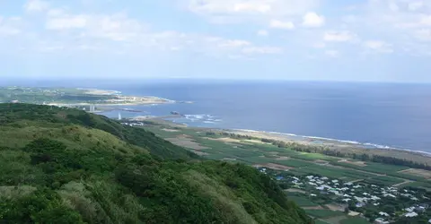
Hyakunodai,Kikai
Snap55, Wikimedia
West Coast Walk
On the south-west coast of the island, the long white sandy beach of Nakazato, whose turquoise waters are home to two coral islets, and that of Sugira, part of the "Airport Seaside Park", behind the airport, are the more popular. A little further west from Sugira Beach begins a 2.4 kilometer long path called "Esplanado" or also "Araki-Nakasato", bordering part of the western coast of Kikai. You will be able to walk along coral and rock formations but also through a grove of banyan trees. In some places you will have magnificent views of the sea . This is the best place on the island to admire the sunset . Further north, Muchakana Park also offers lovely views.
East cost
In the southeast of the island, Nakanishi Park is home to the highest point of Kikaijima (212 meters) from where you can have magnificent views of the island and the Pacific Ocean . Going north, cross Hyakunodai Park and pretty villages, including Aden Village, with low walls made of coral. To the north, Shitooke Beach is perfect for diving. You will even find a campground. The Tonbizaki lighthouse indicates the tip of the extreme north of the island, near Cape Tonbizaki. A little further to the west is a beautiful beach of rocks and white sand, Hawaii Beach .
You can visit Kikai in an hour by car on the 36 kilometer long road that circles the island (but does not always run along the sea). There is also a local bus network. However, the island's ambience and quiet beauty invite you to linger. In summer, its uncrowded beaches, its clear waters inhabited by all kinds of tropical fish and its corals make it an ideal destination for diving enthusiasts .
See also: Scuba diving in Okinawa
Finally, Kikaijima is famous for its Kokuto Shochu , an alcohol made from cane sugar .

Coral walls in a Kikai village
tsuda, Flickr
Address, timetable & access
Address
Timetable
From Tokyo: Go to Kagoshima or Amami from Haneda Airport, then fly to Kikai. Ferries connect Kikai from Kagoshima, Amami-Oshima and some islands of the Amani Archipelago.
